Inland Waterway Transport System
Inland Waterway Transport System
Completion requirements
View
In this section you will learn more about the inland waterway transport system and
its different elements goods, vessels, inland waterways and ports.
This topic follows the structure of the conceptual system model of
transport and traffic.
5. Inland Waterways
Now we deal with the element infrastructure of the conceptual system model, which is in the case of the inland waterway transport system represented by the "Inland waterways".
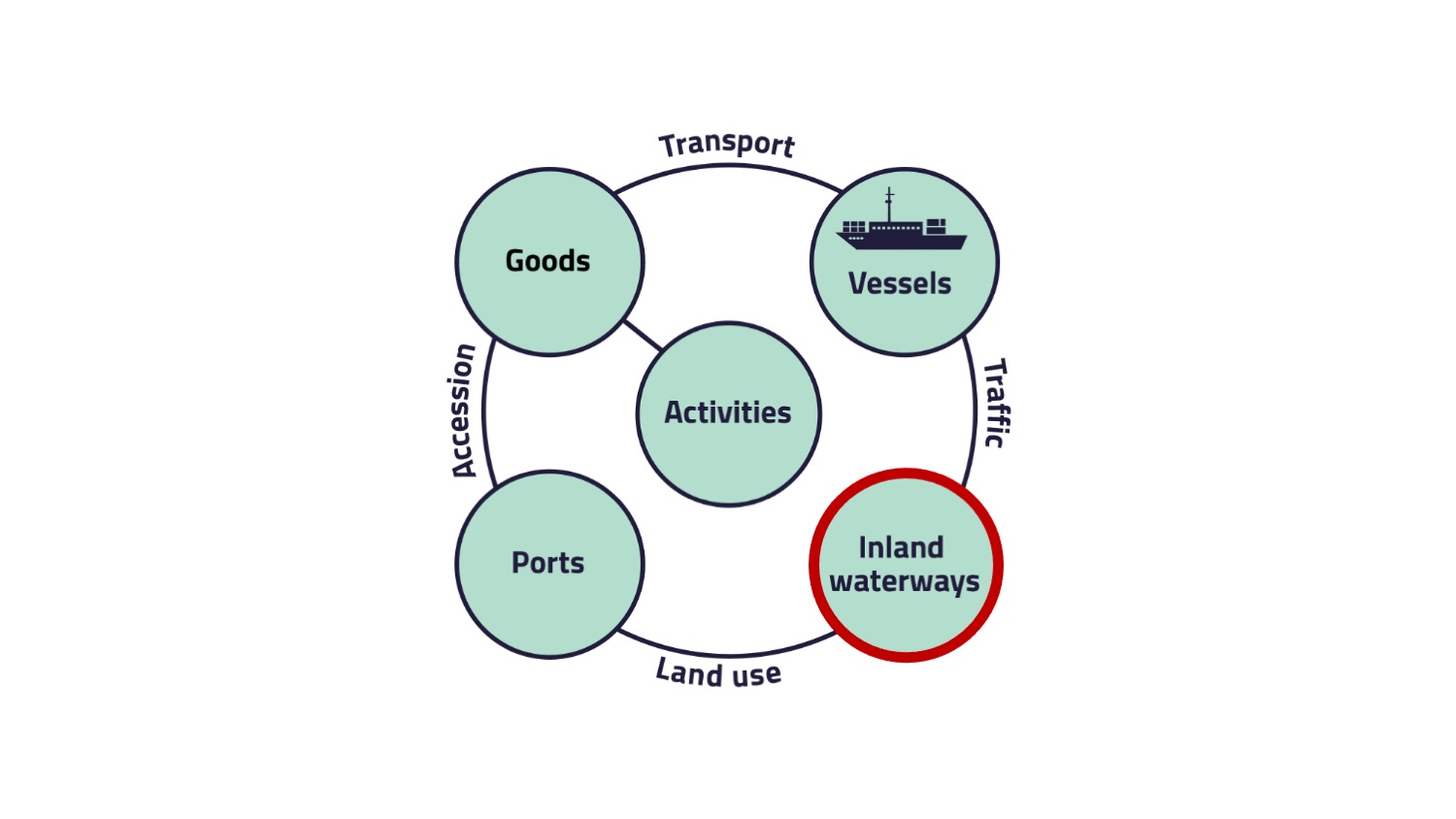
The waterways can consist of various elements, like…
- canals,
- rivers,
- lakes or
- between inland ports and wharves.
European inland waterways
Various waterways run in part across Europe and connect many cities and thus important industrial areas with each other.
The picture "Waterway network in Europe" gives you a rough overview of the waterway network in Europe.
The picture "Waterway network in Europe" gives you a rough overview of the waterway network in Europe.
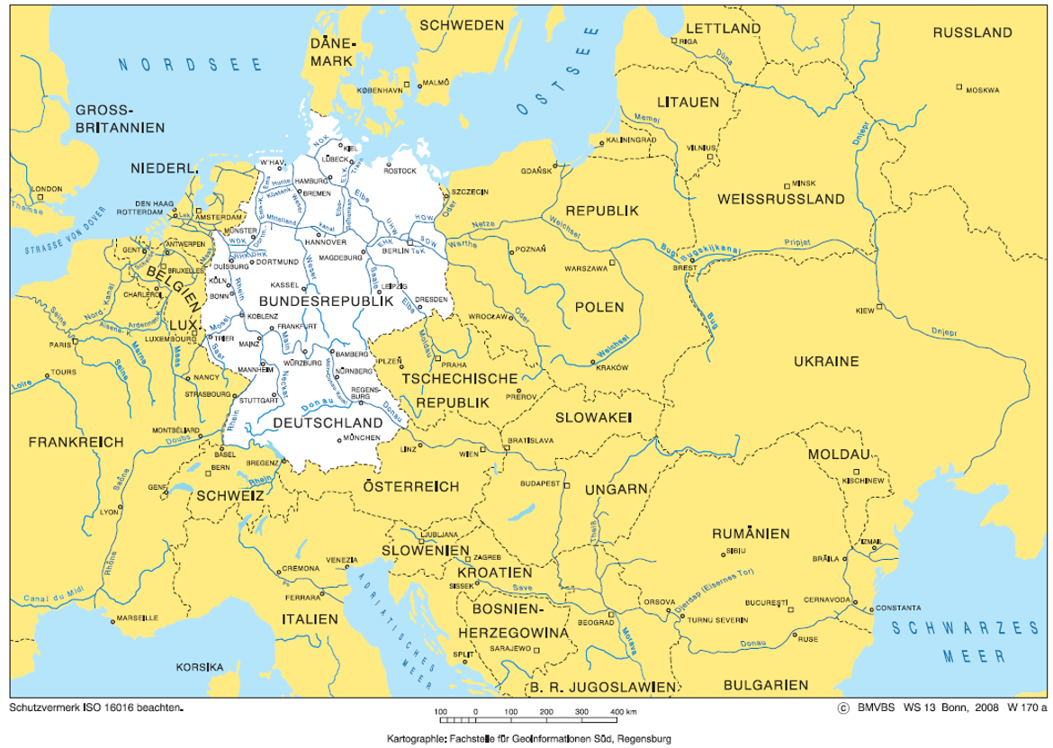
Now that you have a rough overview, let's take a closer look at the inland waterway network in Germany.
German waterway network
German waterway network
In Germany, the inland waterway network is around 7.300 km long (approx. 75 % rivers and 25 % canals) with 315 locks, 307 weirs, 2 ship lifts, 2 dams and 1300 bridges. The inland waterways are divided into different classes according to their navigability. The basis of the classification is the spatial dimensions of matched ship types, of which the horizontal parameters of length and width are the most important. The most important german inland waterway is the Rhine.
German inland waterway priority network
German inland waterway priority network
In 2011, the Federal Waterways and Shipping Administration published the following targets of the modernization concept for the German inland waterway priority network:
- Available resources (material, personnel) will be focused on sections of the waterway infrastructure with already or anticipated heavy traffic.
- Processes and technology should be further standardized and pooled.
- Third parties should be more involved in the task execution (especially for waterways with low traffic importance).
- Shifting freight transport to inland waterways.
Net division
The figure "Waterway network Germany" shows the different waterway networks in Germany.
One network criteria is defined by the scope of the use of a waterway in terms of the annual transport capacity in tonnes. The criteria is based on the transport capacity in 2009 and the forecast of the traffic development until 2025.
The waterways in Germany are divided into different classes depending on their transport volumes. For example on the priority network (red), more than 10 mio. tons are transported, while in the edge network (blue) only more than 0.1 mio. tons are transported.
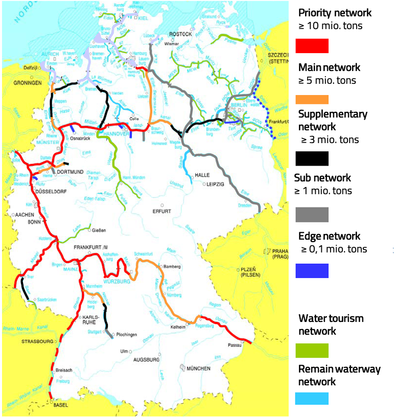
The limits for the assignment of the categories of the inland waterway network are the following:
- priority network: ≥ 10 mio. tons of cargo per year
- main network: ≥ 5 mio. tons of cargo per year
- supplementary network: ≥ 3 mio. tons of cargo per year
- sub network: ≥ 1 mio. tons of cargo per year
- edge network: ≥ 0,1 mio. tons of cargo per year
Impact of network structure on expansion, optimization and operation
There are different strategies for the future development of the inland waterway depending on its category. While the priority network should be expanded with high intensity, the main and the supplementary waterway network should only be optimized with different intensities. The sub waterway network is expanded and optimized with low intensity, meaning that the efforts are not too high for this category. Tasks to expand and optimize the edge and remain waterway network are not perceived anymore. The category also influences the traffic related financing and operation. The traffic related financing and traffic related operation are pursued with high intensity (higher than before 2011) for the priority and main waterway network and with the same intensity as in 2011 for the supplementary and sub waterway network. For the edge and remaining waterway network the intensity is low or tasks are not perceived anymore.
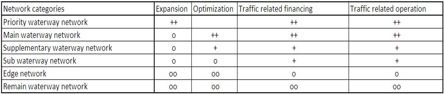
Explanation of the symbols:
++ high intensity
+ same intensity
o low intensity
oo task is not perceived anymore
++ high intensity
+ same intensity
o low intensity
oo task is not perceived anymore
In order to achieve the set goal of expanding or optimizing as well as maintaining and operating the inland waterway network, different tasks are defined by the BMVI (Federal Ministry of Transport and Digital Infrastructure).
Extension of the priority network:
Extension of the priority network:
- Construction of German waterways and hydraulic engineering sites enable the navigability for much larger vessels.
- e. g. new locks, continuously enlarging and deepening of waterways
Optimization of the main- and supplementary network:
- All measures to improve the conditions of navigation.
- e. g. bridge lifting, adjustment of curve radii
Maintenance of all waterways:
- All temporary and permanent conservation measures of the waterway.
Operation of all waterways besides residual network:
- All measures for the maintaining of navigation on the waterways.
Many important economic centers have a direct connection to the inland waterway network and use it for the transport of goods.
A study by Koch, Mahler and Stumpf (2012) defined alternative evaluation criteria's of the German waterway network. In their study, they defined economic centers, evaluated the waterways and categorized the German waterway network.
Define economic centers
The figure "Categorisation of waterways" shows the economic centers that are located at an inland waterway.
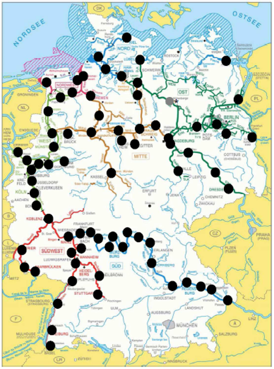
In order to be called an economic center, some criteria’s need to be met:
- More than 10.000 employees in the producing industry.
- A minimum turnover of 1 billion € at the producing industry.
- An Inland Port or a private transshipment point.
In Germany, 75 sites meet the criteria for an economic center.
The inland waterways are evaluated by the multiplication of the amount of goods of an economic center with the value of an economic center which needs to be much higher than the evaluated transportation units. The evaluated transport units are then allocated to the German waterway network.
Categorization of the German waterway network
Categorization of the German waterway network
The waterway network in Germany is divided into 3 main categories:
- Core network (≥ 1.000.000 evaluated transportation units)
- Sub network (< 1.000.000 evaluated transportation units)
- Leisure time network (rest of the waterways)

In order to constantly maintain and also improve the infrastructure, projects are planned to expand the inland waterway network. One example is the Canal-Seine Nord Europe. Here are a few details about it:
Infrastructure project Canal-Seine Nord Europe
Generally:
- Connection between the zone of attraction of the rivers Seine and Schelde.
- Transport of goods between France, Belgium, the Netherlands and Germany.
- Construction from 2012 for opening in 2017; after the election it is put on hold.
- Starting again: 3rd of October 2017 for opening in 2030.
Facts:
- length: 106 km
- width: 54 m
- depth of water: 4,5 m
- category: Vb
Potential impact of the Canal Seine-Nord Europe:
- Improvement of the competitiveness and attractiveness of the crossed regions.
- Connection of the French inland waterway to the European transport network.
- Reduction of road freight transport.
The relation between ports and inland waterways is called land use.
Land use
Many inland ports are located in or near cities and are often being displaced from urban areas. Cities with freight transport concepts, recognize the important role of tri- or bi-modal city ports for the realization of environmentally friendly transport chains.
Literature
BMVBS (2011): 2. Bericht des BMVBS an den Deutschen Bundestag zur Reform der Wasser-und Schifffahrtsverwaltung, Berlin. URL: https://www.dmyv.de/fileadmin/content/_global/_downloads/politisches/Wassertourismus-WSV-Reform/2.%20Bericht%20BMVBS%20zu%20WSV-Reform.pdf (last access: 30.03.2022)
Bundesministerium für Verkehr und digitale Infrastruktur (2021): Bedeutende europäische Wasserstraßen (w170a). URL: https://www.gdws.wsv.bund.de/SharedDocs/Downloads/DE/Karten/Karten_neu/w170a_eur_Wasserstrassen.html (last access: 30.03.2022).
Flämig, H., Sjöstedt, L., Hertel, C. (2002): Multimodal Transport: An Integrated Element for Last-Mile-Solutions? Proceedings, part 1; International Congress on Freight Transport Automation and Multimodality: Organisational and Technological Innovations. Delft, 23 & 24 May 2002. (modification of Sjöstedt 1996)
Flämig, H., Sjöstedt, L., Hertel, C. (2002): Multimodal Transport: An Integrated Element for Last-Mile-Solutions? Proceedings, part 1; International Congress on Freight Transport Automation and Multimodality: Organisational and Technological Innovations. Delft, 23 & 24 May 2002. (modification of Sjöstedt 1996)
Koch, J., Mahler, S.; Stumpf, F. (2012): Management Summary: Vorschläge zur Bewertung der Bundeswasserstraßen unter Berücksichtigung der Aspekte Netzfunktion und volkswirtschaftliche Wertschöpfung. URL: https://www.bonapart.de/uploads/media/120530_Management_Summary_Kategorisierung_Bundeswasserstrassen.pdf (last access: 30.03.2022).
Wasserstraßen- und Schifffahrtsverwaltung des Bundes (2022a): Bauwerke und Anlagen. URL:
https://www.gdws.wsv.bund.de/DE/wasserstrassen/02_bauwerke-anlagen/bauwerke-anlagen-node.html (last access: 30.03.2022).
Wasserstraßen- und Schifffahrtsverwaltung des Bundes (2022b): Bundeswasserstraßen.
URL: https://www.gdws.wsv.bund.de/DE/wasserstrassen/01_bundeswasserstrassen/bundeswasserstrassen-node.html (last access: 30.03.2022).
Wasserstraßen- und Schifffahrtsverwaltung des Bundes (2021b): Klassifizierung der Binnenwasserstraßen. URL: https://www.gdws.wsv.bund.de/DE/wasserstrassen/01_bundeswasserstrassen/Klassifizierung/Klassifizierung_node.html (last access: 30.03.2022).